

Part 2 - Smarter Flood Resilience and Catchment-Scale Thinking
- Sep 24, 2025
- 3 min read
Updated: Oct 3, 2025
Nature-based Solutions in New Zealand
Updated: 24/09/2025
By Vision Consulting Engineers (VISION)
In This Article: - A clear definition of Nature-based Solutions (NbS). - Why New Zealand's changing climate requires a new approach to catchment management. - The four key principles for planning a successful NbS project. - A real-world example of a landowner information pack.
Flooding, erosion, sediment, and degraded water quality are nothing new to most Northlanders. But the way we’re dealing with them is changing. Across Aotearoa New Zealand and internationally, Nature-Based Solutions (NbS) are gaining momentum as a practical, cost-effective way to manage water, protect land, and restore ecosystems, along with many other “co-benefits”.
What are Nature-based Solutions?
At their core, NbS are ways of using natural processes to tackle environmental and social challenges. Instead of hard engineering (like concrete channels or pipes), NbS help transition back to natural landscapes and might involve:
Planting steep slopes to reduce erosion.
Planting riparian corridors to stabilise stream banks and keep water temperatures down.
Using silt traps to keep sediment out of awa (rivers).
Creating repo (wetlands) to slow runoff, improve water quality, and enhance habitat.
Installing “leaky” timber barriers in overland flow paths or small streams to “slow the flow”.
Reconnecting a river to its floodplain to improve water storage, reduce erosive forces, and reduce flooding
Creating intertidal habitat in predicted flood zones from sea level rise.
Managing catchment activities that can have a high environmental toll through enabling innovative technologies, strategic planning or using traditional local methods.

Why Does New Zealand Need a Different Approach?
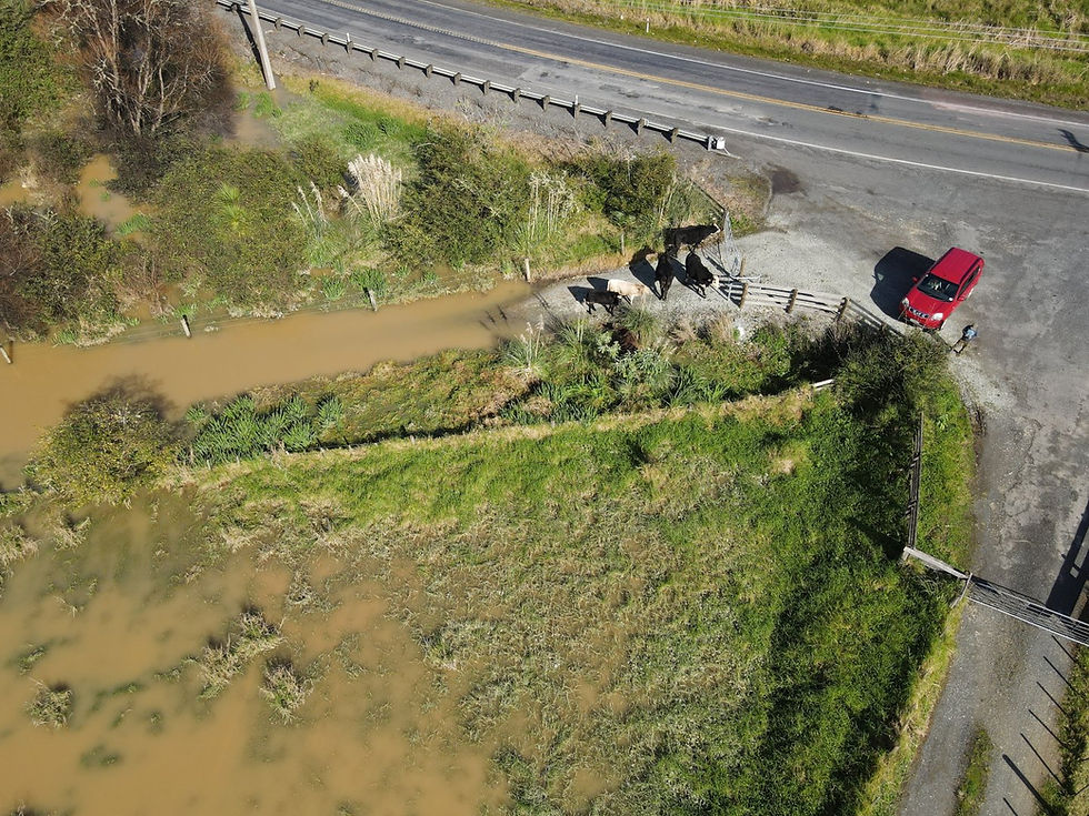
Northland’s climate is changing with shifting timings of rain, more intense storms and frequent droughts. This is a similar pattern to many places around New Zealand and steep erosion-prone land with heavy clay or weak soils are vulnerable to slips and sediment loss during storms. Many waterways are modified, straightened, drained, and un-fenced, leaving them exposed to instream erosion, habitat loss, water quality issues, and expensive maintenance.
With NbS, we don’t want to stop people working on their land, or restore every inch of the catchment; but we do need smarter strategies that consider where and when we should do the hard mahi (work) and how best to work with nature.

How to plan Nature-based Solution Projects
To do NbS projects well, they need to be:
Technically planned (using hydrological modelling and GIS mapping etc).
Site-specific (not every paddock needs a wetland).
Culturally informed (Ngāti Hine and other hapū are leading this community-led restoration work).
Costed, fundable, and feasible.
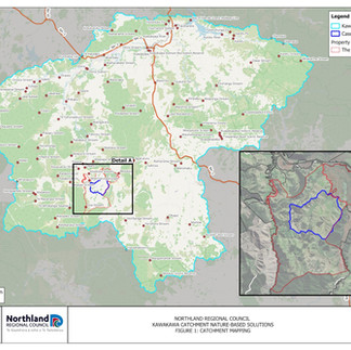
In the Taumārere NbS project, we completed a catchment-wide feasibility study to prioritise restoration using local knowledge, hydrological and hydraulic analysis, and GIS mapping. Methods and NbS types were selected for local conditions with the goal to find real sites, identify suitable actions, and empower local communities to take the next steps themselves.
The gallery below gives an example of a typical project information pack that can be provided to those interested in undertaking NbS projects.


Why We’re Sharing This Now
We know there’s a growing appetite for nature-based flood mitigation, often called "natural flood management" and the co-benefits of NbS projects, but that there is also a lot of confusion.
We’re sharing this blog series to unpack what NbS really means for landowners, councils, and community groups in Northland and further afield.
Future posts will answer the following:
Where do NbS work best?
What do NbS look like on the ground?
How much do NbS cost and who pays?
How do I monitor NbS?
NbS aren’t a silver bullet, but they are one of the most promising tools New Zealand has to adapt to climate change, manage hazards and risk, and restore catchments. The key is knowing where, how, and why to use them...
Explore the Complete Project:
This article is part of our five-part technical series on the Taumārere project. For a comprehensive overview, interactive maps, the full technical reports, and the project webinar, please visit our central case study hub.


Comments